It was not our intention to write another full article on the long-term developments planned at East Croydon. As far as we could see the overall plan was almost finalised and little new was expected to come out of the consultation planned the first half of 2020. However, the most recent consultation details include a lot of changes.
Indeed, the information available is now far more detailed, which gives us a reason to look one more time at the plans for East Croydon. Also influencing our decision to revisit this is COVID-19. This has meant that the requirement for short and medium term enhancement schemes is questionable and it is only the long term schemes – especially the long term schemes that have already had a considerable amount of work carried out – that can meaningfully be reported on. Only they have a business case that isn't completely distorted by the impact of the virus.
A name for the scheme at last
For years we have struggled with what to call the scheme to remodel East Croydon station and junctions north. Last year the overall scheme was announced as the Croydon Area Remodelling Scheme (CARS) but that included work at Norwood Junction station, which could be carried out within the railway boundary under permitted development rules. What was needed was a name for the part of the scheme not covered by existing development rights and therefore liable to a public inquiry.
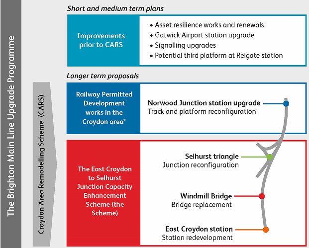
The scheme in question now has a formal name. It is 'the East Croydon to Selhurst Junction Capacity Enhancement scheme'. This is a little long-winded perhaps, but at least it describes its purpose very clearly in one sentence. Note that its objective is increasing capacity. It is not about rebuilding East Croydon station. Work on the station is a consequence of the scheme, not a primary objective.
A tweak or a fundamental revision?
At first glance, the latest details given suggest a much-revised scheme. Indeed, many media articles have reported it this way with the general headline that East Croydon station is to move 100 metres to the north. The Network Rail project team deny that anything much has changed and say this was the plan all along. This is largely, but we would argue not entirely, true. Another way of looking at it is that various relatively small changes have been made which Network Rail may not consider to be especially significant but, from the public perspective, suggests a scheme that passengers will find considerably different from that which has appeared or been implied before in consultations.
The actual changes
As far as we can tell, there are three changes of significance. They are:
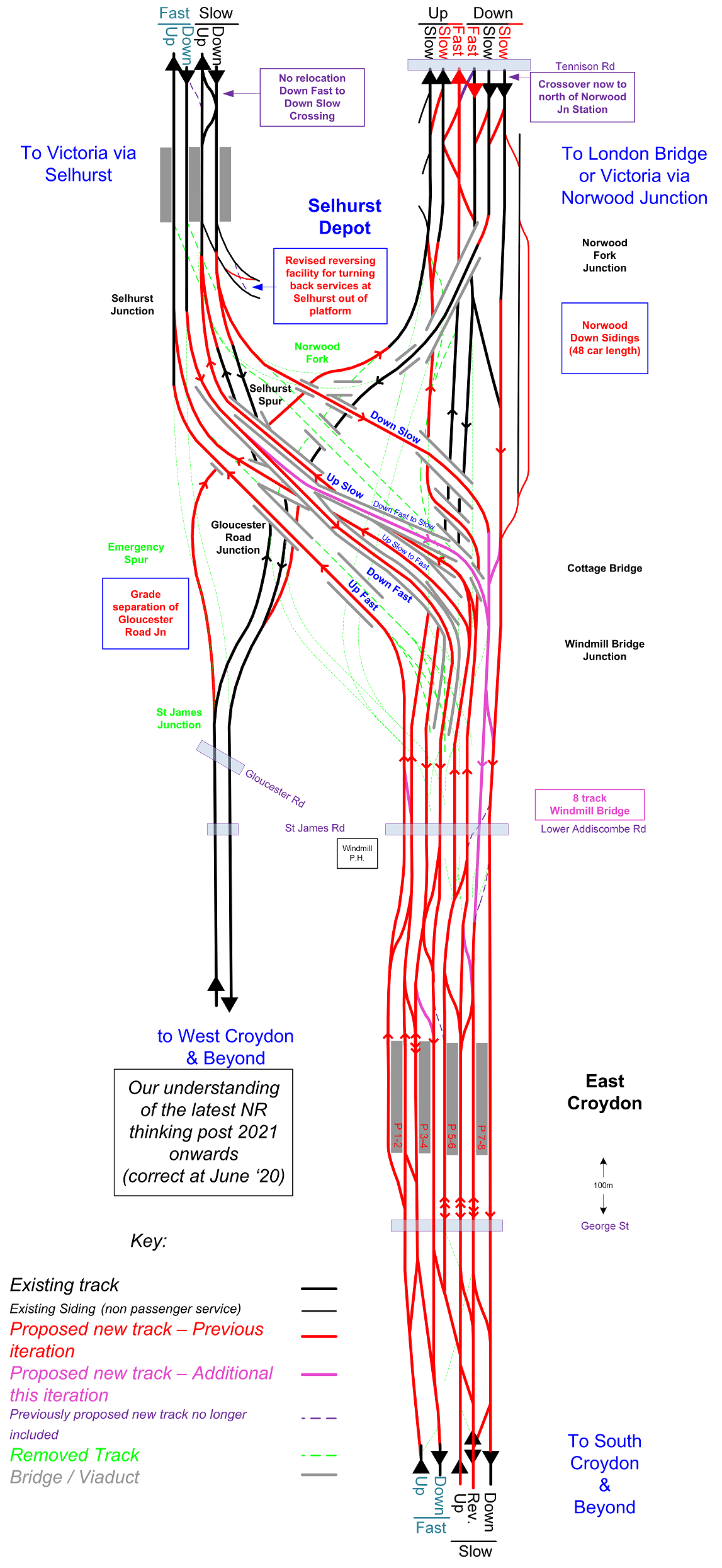
- An eighth track under Windmill Bridge (up from seven).
- A conflict free route from the Victoria Down Fast to the Down Slow at East Croydon has been added (in fact there was always passive provision for this, although this fact was not generally made public).
- East Croydon station appears to have moved 100 metres to the north compared to previous plans. More accurately, the platforms now have a common alignment and existing main station entrance has been replaced by an upgraded entrance around 100 metres to the north of it.
We will look at these in more detail.
Windmill Bridge and the surrounding area
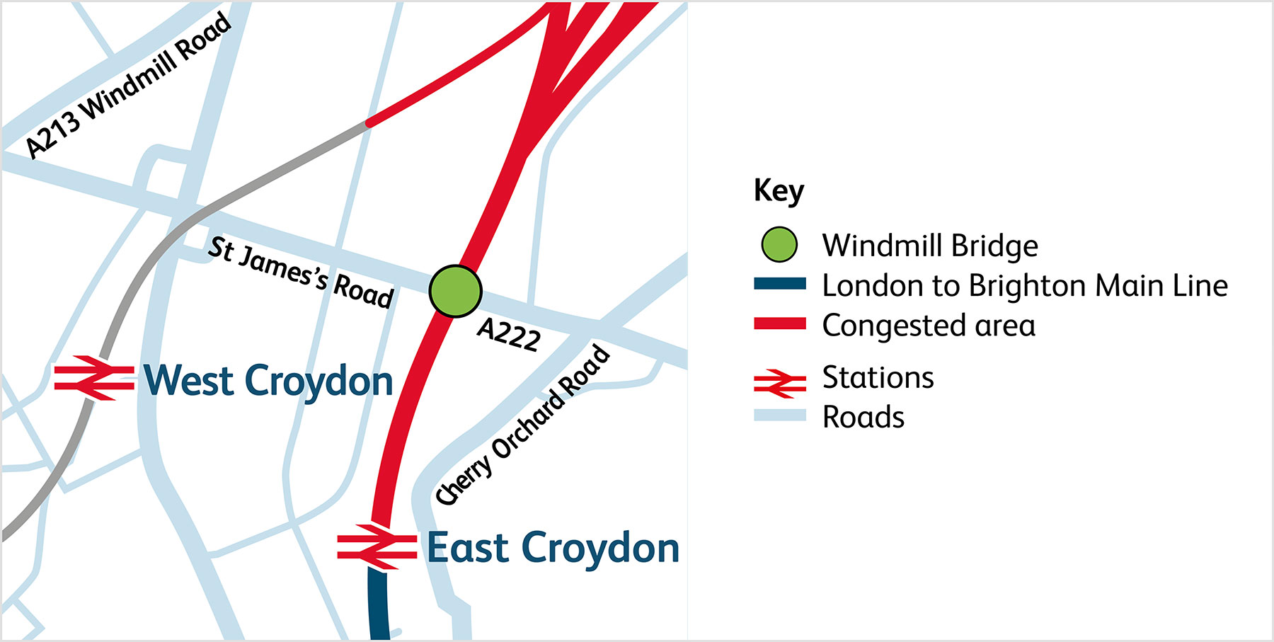
Windmill Bridge (also known as St James' Road Bridge) was always going to be a major part of the capacity enhancement scheme. The road-over-rail bridge currently supports five tracks. It was going to be seven and is now going to be eight. By adding a final eighth track, the plan has avoided some undesirable conflicting (and potentially capacity and reliability reducing) movements between Selhurst and East Croydon station.
In terms of land take, the extra track is not that significant as it does not require any major re-thinking on the design of the bridge. What has changed, or at least now been brought to the public's attention, is the requirement to close the southern end of Gloucester Road. This road runs roughly parallel with the railway at railway level, before rising on a ramp to form a T-junction with the road over Windmill Bridge.
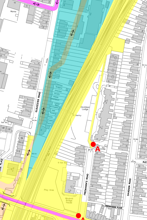
Network Rail argue that plans to close this road are nothing new, but the details of these plans certainly weren't well known. Even less clear previously (and still not immediately obvious) is the fate of around thirty former railwayman's cottages in Gloucester Road backing on to the railway. It was clear in the past that at least one of these would have to be demolished and that others would, as a minimum, have a reduced garden.
What is now apparent, but perhaps technically not a change of plan, is that all these cottages will now need to be acquired and demolished. This is clear because the land is marked as essential for construction. The buildings have to go, even if some of the land can subsequently be made available again for housing once the scheme is complete.
Thirty or so cottages might not sound like a big deal, but the general principle adopted with construction projects in the public interest is to avoid taking private domestic property whenever possible. Thirty domestic properties is actually quite a lot for a railway enhancement programme involving no additional route mileage. Business premises, which form the bulk of the site, are generally not so well protected from compulsory purchase orders as the prevailing attitude is that businesses can be compensated for the inconvenience with no undue hardship caused.
The need for the destruction of so many domestic properties could go some way to explain why it took so long to come up with a plan to eliminate the bottleneck at East Croydon. Unless it is accepted that a considerable number of domestic properties need to be compulsorily purchased, a scheme would only provide marginal benefit. The only alternative is going to the extreme lengths of proposing a long tunnel emerging south of Purley - which was what Network Rail proposed about a decade ago.
Bridge reconstruction
Network Rail have now made it a lot clearer how they intend to reconstruct the bridge and have produced an excellent animation which includes this.
It was always clear that the intention was to 'boom over' or launch the new bridge. This is now quite a common practice. The big advantage for Network Rail is that you don't have to close the railway to do it. So common is this practice now that just over a mile away from Windmill Bridge is Tennison Road bridge which was installed in the same manner a few years ago. An even closer example is the recent foot overbridge at East Croydon station which was installed in a like manner.
What complicates things at Windmill Bridge is that it is impractical to close the road for a long period to enable the offline bridge construction to take place. There are other factors too. Network Rail have obtained ownership of a worksite in the south-west corner of the bridge and there is also a desire to maintain at least pedestrian and cycle access at all times. Furthermore, the revised road layout has to comply with modern highway standards which makes locating the new bridge in any location other than the same one as the old bridge an impractical option.
Windmill Bridge is actually the only crossing point between the previously mentioned Tennison Road bridge and East Croydon station foot overbridge. This highlights how vitally important it is to maintain at least pedestrian access (and preferably cycling access) during the time that the bridge is out of use to motor traffic.
The solution that Network Rail have proposed is to slide the bridge in two stages. The first stage places it parallel but slightly to the south of the final position and the second stage slides it north so it sits where the existing bridge resides.
Although engineers nowadays are highly skilled at installing new bridges without closing the railway, they have yet to find a means of removing old brick bridges without a railway closure. So the sequence is a follows:
- Build temporary trestles to support the new bridge just south of the existing bridge
- Boom across the new bridge to rest south of the existing bridge onto the temporary trestles
- Open new bridge in its temporary position with temporary approaches for pedestrians and cyclists only
- Close existing bridge and demolish
- Build two outer piers for the new bridge to rest on
- Boom new bridge into position

Note that the new bridge in its final position, like Tennison Bridge, will not need any intermediate pier supports between the railway tracks.
Below is an excellent video from Network Rail. Three minutes into it is an animation that shows, far better than words can, how of how the bridge will be put into place should the scheme go ahead.
The plan was always to make the final in-place bridge more friendly to pedestrians and cycling, but now there is also talk of pedestrian and cycle routes beneath the bridge parallel to the railway. For cyclists in particular this is potentially a major advantage as the A222 (Windmill Bridge Road) is quite a barrier for cyclists wishing to go from north to south or vice-versa.
Eighth track completes the set
One weakness with the earlier proposals was that most rail routes were conflict free, with the notable exception of trains on the fast lines from Victoria crossing over to the slow lines at East Croydon and continuing southwards on the slow lines. These would include trains heading to East Grinstead, which cannot remain on the fast lines as they need to access the junction at South Croydon via the slow lines.
Network Rail had known this remaining conflict would be a weakness, but modelling showed that the proposed arrangement would work. Nevertheless, it was one of those situations where it just felt wrong. Its omission destroyed a certain symmetry with track layout and it is intuitive to think that, if East Croydon station will have eight platforms, it makes sense to have eight tracks under Windmill Bridge.

It seems Network Rail have revisited their plans and decided to incorporate the eighth track from the outset. This has clearly made incorporating this into the footprint available even more challenging, but Network Rail have succeeded in producing a workable layout with eight tracks and no pinch points. Inevitably it will be a layout with compromises. For example, provision is made for overhead electrification should that ever be required in the future, but clearances will be tight. Also, the gradients are acceptable, but it would have been desirable if these could have been reduced. It is easy to forget that the Brighton Main Line is also a freight route with regular freight workings.
East Croydon station changes
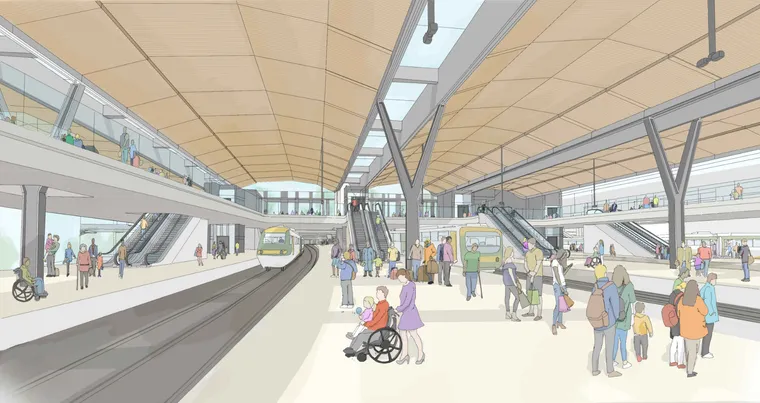
To the average member of the public travelling by train, all that is important is knowing what East Croydon station will look like and what services will be offered. The station appears to be radically different than proposed before but, in a sense, not that much has actually changed.
On the previous iteration of the scheme, the new platforms 1-4 would have been set to the north of the new platforms 5-8 (existing platforms 3-6). This is largely because it is only possible to get a maximum of seven tracks under George Street railway bridge outside the current main station entrance. So, it seems fairly sensible to move the new platforms 5-8 so that they line up with new platforms 1-4. This immediately produces the benefit that Network Rail will not be so tightly constrained by land boundaries as they would be if the platforms reached almost as far south as the current station entrance.
Possibly one of the biggest advantages of moving the centre of gravity of the station further to the north is that it provides an opportunity to retain the relatively-new wide station foot overbridge complete with lifts. This has been rather cleverly incorporated into a new entrance to the station. This bigger station entrance means that the existing station entrance can be abandoned and a large open space created in front of the new, more substantial, station entrance.
The existing entrance goes
One perceived downside of this new plan is that it involves the demolition of the 1992 Network SouthEast glass atrium that is the current main station entrance. A life of around 30 years for a station building suggests a failure of planning, but sometimes circumstances come along which mean it makes sense to demolish. Abbey Wood is an obvious example of another, relatively new station building being rethought for a greater benefit.
As much as anything, the need to demolish the big glass atrium and replace it with a glass atrium that is even bigger is an indication of how much rail traffic has grown at East Croydon.
The oversite building – abandoned
One thing that will probably go down well with users of the new station is the lack of oversite development. Network Rail seemed to have bowed to the inevitable here, because it was largely unbuildable. Or rather, it could be built, but was starting to raise formidable challenges – particularly when it came to a construction plan that was consistent with keeping the railway open.
Residents of Croydon in general will be relieved that additional tall buildings will not now be built. In recent years, the station has become increasingly surrounded by them and a low-rise station will go some way to avoid even more of a Manhattan look. It will also provide some much-needed open space.
The Piazza that could be even bigger
Perhaps the most dramatic change to the scheme is the amount of open space created, with the new station main entrance on one side and the existing tram stop on the other. This is clearly not going to please everyone.

Large open spaces, sometimes amounting to full continental-style piazzas, are very much the in thing. King's Cross now has a dramatic open setting and even London Bridge has some open space outside its Tooley Street entrance. Visually, the proposed one at East Croydon will probably be fairly attractive, even if Network Rail plan to have small retail outlets on three sides of a large light well allowing daylight below. The piazza will also give a feel of spaciousness – something the existing East Croydon station is severely lacking.

What is frustrating is that the area between the station entrance and tram stops could potentially be an even larger welcoming open space. The retail units could be relegated to the extremities – as they are at King's Cross.
For Network Rail though, this presents a problem. The trackwork that needs to be rebuilt below this potential piazza is complex and already this is a bit of a construction logistics nightmare. Full decking over is awkward and would add considerable cost to the scheme, making Network Rail concerned that this would impact on the scheme's overall viability.
Interchange with buses and trams
One downside of the scheme is that interchange with buses and trams is not going to be anywhere near as convenient as today. That said, in fine weather this shouldn't prove too much of an issue and the separating space is needed. In recent years there has been a trend not to make interchanges too convenient with only a nominal interchange distance. This is because of the issue of crowd build-up when problems occur and the difficulty of managing that in a confined space.
A plus point could be that at the moment, when East Croydon gets shut down due to a suspicious package or other incident, it tends to be a shutdown of both trains and trams (and sometimes buses too). If there is some distance between the tram stop and the railway station the perhaps future shutdowns will not be so severe.
Future interchange options
Clearly, with the proposed piazza, both Croydon Council and TfL are going to show a major interest in the design of services outside the station. The word is that they are not against the revised proposals, but see the need to get involved in order to take advantage of the opportunities made available. One obvious issue is the lack of a covered route from the station to the tram stop. More positively is the possible opportunity to revise East Croydon's tram layout to cater for four tracks with two wide island platforms and hence better interchange arrangements between different tram routes.
Taking speculation to extreme lengths, one wonders if there is an opportunity for a tram loop around the piazza so that some tram passengers could pick up the tram from almost outside the station. This would fit in with the long term plans for trams to have increased frequency on the Wimbledon route and, to avoid too many trams in the town centre, turning some of the New Addington trams at East Croydon. This was the idea of the now-defunct Dingwall Road loop. It must be emphasised that nothing has yet been officially suggested as a way to tackle interchange issues at the revised East Croydon station.
Urban Realm
Just as nothing is decided regarding interchange options, nothing has been decided about urban realm. Traffic-free drawings of the area surrounding East Croydon station portrayed in the consultation are pure speculation. Network Rail's consultation page seems to suggest that Dingwall Road would be pedestrianised, but this appears to be on the basis that nothing definite is known but Network Rail need to show something.
Another new entrance
The revised plans show a new entrance for the station in Lansdowne Road, north of the existing entrance which is reached via Caithness Walk. This would be linked at ticket hall level with the new main entrance. The proposal for this additional entrance is not new, but has more significance now that the station will only have two entrances.

One problem for Network Rail is anticipating how big the entrances need to be. With COVID-19 probably delivering the final coup de grâce to the proposed town centre shopping development in Croydon – originally intended to be complete in 2018 and not yet started – no-one really has any idea how Croydon will develop over future years. All Network Rail can do is make each entrance large enough for the maximum number of expected people.
Additional Services
Looking at the physical aspects of the scheme, it is easy to forget that the purpose is to increase capacity. According to the consultation, this scheme will result in an extra two trains per hour to Victoria, an extra two to London Bridge (terminating) and an extra two Thameslink services.

Of course, on the modern railway, schemes potentially increasing capacity do not necessarily mean that the increased capacity is used. And, because it is subject to a separate consultation led by the DfT and TOCs, which services (if any) will benefit is a matter of separate discussion. It is important to point out that, if the scheme goes ahead, East Croydon and the surrounding junctions will no longer be the limiting factor. If further capacity enhancement schemes went ahead (e.g. at Clapham Junction), then East Croydon could accommodate any extra services that could be provided.
The hidden extra two trains per hour
If the scheme went ahead it would enable a total of an extra 6tph through East Croydon. That may not sound like much, but with each 12-car train potentially carrying between 1000 and 1500 extra people, that is a lot of increased capacity.

Not so important in terms of overall capacity but important in terms of better service, is the potential to run an extra 2tph on London Overground to West Croydon. Running 24tph on the East London line has long been a cherished dream of TfL. Long term, the challenge is to get 6tph to West Croydon (with 3tph continuing to Wallington to terminate there due to limited turnback capacity at West Croydon).
The scheme, if implemented, will make it possible for TfL to run 6tph to West Croydon, but the necessary trackwork would not be implemented until stage 2 (of 3) of the construction scheme, so would not happen until the late 2020s at the earliest.
The Thameslink quandary
The statement that the scheme will enable an extra 2tph on Thameslink through East Croydon raises some interesting questions. Thameslink allows for a maximum of 24tph through central London and all these slots are spoken for, although not all of them are yet in use. The only way you can get an extra 2tph Thameslink service through East Croydon is by removing it from elsewhere.
The obvious service to divert is the 2tph Thameslink service through London Bridge to Rainham. This was very controversial at the time but seems to have settled down and works well. It is, however, only an 8-car service, so it would be good if it could be replaced by a 12-car one. Of course, extra carriages would have to be ordered.
The problem with diverting the Rainham service is that it is established and could well be regarded as an unexpected success. The feared problems in introducing it haven't materialised and, as it utilises otherwise unavailable paths (due to limited capacity at Cannon St), it would be difficult to provide a replacement service.
Another option is to not implement the proposed Thameslink Cambridge – Maidstone East service and divert that to run via East Croydon. Politically this might be difficult. Not only that, but a new depot at Chart Leacon in Ashford is being built for maintaining the trains that would run this service. Due to platform length restrictions, north of Hitchin semi-fast Thameslink services to Cambridge are currently only 8-cars long so this would not be an ideal candidate.
The third alternative is reduce the number of Thameslink trains running via Elephant & Castle by 2tph. To those at London Reconnections there is an obvious choice: those that run via the Wimbledon loop. This would be a huge reliability improvement. Currently there are 2tph through Wimbledon loop services in each direction. However, this service was controversially retained to satisfy popular demand, despite it not being Network Rail's original intention to run such services after Thameslink rebuilding was complete. It would remain challenging politically to remove 50% of this through service despite the considerable operational benefits.
The remaining possible services to be culled to provide more Thameslink services through East Croydon are the ones to Orpington and Sevenoaks (both via Elephant & Castle).
Disruption during construction

Those who have endured reconstruction of Blackfriars or London Bridge for many years will be relieved to know that services should not be greatly affected by construction work. The crucial area is East Croydon station and the designers believe they can keep five platforms open at all times. Unlike at London Bridge, the total number of platforms is being increased. This has a huge benefit in that you can build a new platform (the new platform 1) and then effectively have three platforms out of service during construction. Once platform 1 is complete platforms 2 (as yet unbuilt), 3 and 4 are taken out of service and reconstruction commences. Then 2 comes in service and 5 goes out of service and so on.


If East Croydon temporarily had five platforms, these would almost certainly be used as Up Fast, Reversible Fast, Down Fast, Up Slow and Down Slow. Note that because of signalling restrictions due to a lack of a safe signalling overlap, today's reversible platform 5 cannot be effectively used as a through route in the up direction. As a result, platform 4 is effectively the only up slow line.
Although East Croydon today is nominally a station with six through platforms, platform 5 is not timetabled for many through trains. Its leading role at present seems to be to allow trains from Milton Keynes to terminate, and to enable slicker operation with a short notice platform alteration when southbound slow trains are bunching up. The proposal is to terminate the Milton Keynes trains short of East Croydon – probably at Selhurst (using the depot to terminate and commence the return journey) or West Croydon. Not mentioned as a possibility is to run the trains through to South Croydon (where they originally terminated) or even Sanderstead. Presumably the desire is to avoid them adding to the traffic at East Croydon even as trains that are not terminating.
Is the scheme still needed?
With COVID-19 still in the air some would question the need for such a scheme. Even if we get over the current situation, it is argued that commuting and other travel habits will have changed forever.
Whilst it may be true that COVID-19 could change attitudes permanently, the probable result would only be to accelerate existing trends when it comes to working from home and working more flexibly. All the evidence so far points to this causing people to commute for fewer days a week, but this is offset by a rise in longer distance commuters who are prepared to pay the price of a longer, but less frequent, commuter journey in order to live in what they see as a more desirable area. As such it is expected that the demand for commuting through East Croydon will remain high. COVID-19 has also taught us that the latent demand and desire to travel for leisure has not reduced.
Whilst it might be foolhardy to fully commit to this scheme in 2020, it would make sense to continue to develop it, given how much work has already been done. There is still a long way to go before there are 'shovels in the ground'.
It also has to be borne in mind this scheme is probably a one-off opportunity. Signalling needs replacing in the next few years and Network Rail has already acquired a lot of land that it cannot hold onto indefinitely. If this scheme did not go ahead it would be extremely hard to increase the capacity of the Brighton Main Line in future and, with East Croydon the critical bottleneck, schemes elsewhere would just not achieve the necessary result.
Next stage
Because of COVID-19 and the lack of face-to-face consultation, the consultation period is longer than normal, ending on Sunday 20th September 2020. Once Network Rail have received their responses, they will prepare a Transport and Works Act submission and apply to the Secretary of State for Transport for a Transport and Works Act Order. It is expected that there will be a public inquiry in 2022. Passengers would start to see benefits by 2028 but the full scheme is not expected to be complete before 2033.
The Network Rail consultation page can be found here. It is very detailed with many detailed maps, diagrams and images as well as animated videos. All images in this article have been taken from the Network Rail consultation pages. Our apologies for the lack of accompanying area pictures. This is due to COVID-19 travel restrictions. Thanks, as always, to ngh for the updated track diagram.
Like what you have read? LR is community funded! You can back us on Patreon here. Every little helps...